

Preview
Date
Winter 2-1978
Description
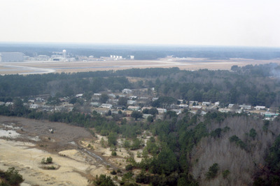
This aerial photograph shows housing around the borders of Charleston International Airport. The airport is a joint civil-military airport, which was privately constructed in the 1920s. During World War II the US Army began using the airport as part of the eastern defense program. The airport was acquired by Charleston county in 1979 and continues joint operations at present.
Rights
This object from the Chester E. Smolski photographic slides and publications, housed by the Rhode Island College Special Collections, and any of its digital surrogates are the intellectual property of Rhode Island College. This digital object is protected by copyright and/or related rights. The digital material presented here is licensed with a Creative Commons Attribution-NonCommercial-ShareAlike 4.0 International License. This content can be used, shared, or adapted for educational and scholarly purposes. For permissions to use this item please contact digitalcommons@ric.edu. All uses must include appropriate attribution.
Creator 1 Role
Photographer
Recommended Citation
Chester E. Smolski photographic slides and publications, MSS-0041, Special Collections, James P. Adams Library, Rhode Island College.
Recommended Citation
Chester E. Smolski photographic slides and publications, MSS-0041, Special Collections, James P. Adams Library, Rhode Island College.
Keywords
housing, airport, aerial, suburb
Notes
http://en.wikipedia.org/wiki/Charleston_International_Airport
(accessed 9 Dec 2011)
http://www.chs-airport.com/aphist.htm
(accessed 9 Dec 2011)