

Preview
Date
1983
Description
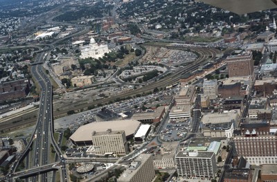
Here we see how the former Chinese Wall of train tracks had prevented the downtown development from reaching the capital. The center of the city is essentially a parking lot along the parameter of the downtown financial district. What we see is the future development of the Capital Center.
Rights
This object from the Chester E. Smolski photographic slides and publications, housed by the Rhode Island College Special Collections, and any of its digital surrogates are the intellectual property of Rhode Island College. This digital object is protected by copyright and/or related rights. The digital material presented here is licensed with a Creative Commons Attribution-NonCommercial-ShareAlike 4.0 International License. This content can be used, shared, or adapted for educational and scholarly purposes. For permissions to use this item please contact digitalcommons@ric.edu. All uses must include appropriate attribution.
Creator 1 Role
Photographer
Recommended Citation
Chester E. Smolski photographic slides and publications, MSS-0041, Special Collections, James P. Adams Library, Rhode Island College.
Recommended Citation
Chester E. Smolski photographic slides and publications, MSS-0041, Special Collections, James P. Adams Library, Rhode Island College.
Keywords
highways, Capital Center, aerials, urban design, land use, city planning, urban renewal, Providence Place Mall, Waterplace Park, Rhode Island State House, Dunkin Donuts Center, Hilton Hotel (former Holiday Inn)
Notes
Leazes, Fancis J. and Mark T. Motte, Providence, the Renaissance city (Boston: Northeastern University Press, 2004), 115-123. Describes the development of the Capital Center Plan into the River Relocation Plan by William Warner in 1984.