

Preview
Date
8-1-1964
Description
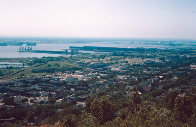
The St. Louis River flows into Lake Superior. Duluth, which is located on the banks of the river and Lake Superior, experienced tremendous industrial growth during the 19th and twentieth centuries which created large amounts of pollution in the water. By 1975 it was an EPA area of concern. Because of large efforts to clean the river in the last quarter of a century the river is significantly less polluted today.
Rights
This object from the Chester E. Smolski photographic slides and publications, housed by the Rhode Island College Special Collections, and any of its digital surrogates are the intellectual property of Rhode Island College. This digital object is protected by copyright and/or related rights. The digital material presented here is licensed with a Creative Commons Attribution-NonCommercial-ShareAlike 4.0 International License. This content can be used, shared, or adapted for educational and scholarly purposes. For permissions to use this item please contact digitalcommons@ric.edu. All uses must include appropriate attribution.
Creator 1 Role
Photographer
Recommended Citation
Chester E. Smolski photographic slides and publications, MSS-0041, Special Collections, James P. Adams Library, Rhode Island College.
Recommended Citation
Chester E. Smolski photographic slides and publications, MSS-0041, Special Collections, James P. Adams Library, Rhode Island College.
Keywords
Saint Louis River, water front, pollution, aerial, Duluth
Notes
http://en.wikipedia.org/wiki/Saint_Louis_River (accessed 26 June 2012)