

Preview
Date
Spring 3-1978
Description
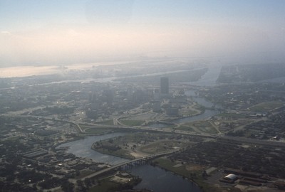
Pictured is an aerial view of the Hillsborough River in the city of Tampa, Florida. The river originates in The Green Swamp located in central Florida and flows downward for 59 miles until it empties into Tampa Bay. The middle river is the city of Tampa’s primary source of water and is filled with an ecological diversity of organisms.
Rights
This object from the Chester E. Smolski photographic slides and publications, housed by the Rhode Island College Special Collections, and any of its digital surrogates are the intellectual property of Rhode Island College. This digital object is protected by copyright and/or related rights. The digital material presented here is licensed with a Creative Commons Attribution-NonCommercial-ShareAlike 4.0 International License. This content can be used, shared, or adapted for educational and scholarly purposes. For permissions to use this item please contact digitalcommons@ric.edu. All uses must include appropriate attribution.
Creator 1 Role
Photographer
Recommended Citation
Chester E. Smolski photographic slides and publications, MSS-0041, Special Collections, James P. Adams Library, Rhode Island College.
Recommended Citation
Chester E. Smolski photographic slides and publications, MSS-0041, Special Collections, James P. Adams Library, Rhode Island College.
Keywords
downtown, Tampa, Florida, Hillsborough Bay, Tampa Bay, rivers, aerial
Notes
http://www.swfwmd.state.fl.us/education/interactive/watershed/map.htm
(accessed 23 Apr 2012)
http://en.wikipedia.org/wiki/Hillsborough_River_(Florida)
(accessed 23 Apr 2012)