

Preview
Date
1990
Description
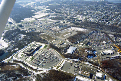
This photograph shows industrial and commercial developments in East Providence along state highway 114. Just barely visible on the horizon is Narragansett bay. The containers on the bay have since been torn down and the area has largely returned natural growth along the East Bay Bike Path, which was completed in 1992.
Rights
This object from the Chester E. Smolski photographic slides and publications, housed by the Rhode Island College Special Collections, and any of its digital surrogates are the intellectual property of Rhode Island College. This digital object is protected by copyright and/or related rights. The digital material presented here is licensed with a Creative Commons Attribution-NonCommercial-ShareAlike 4.0 International License. This content can be used, shared, or adapted for educational and scholarly purposes. For permissions to use this item please contact digitalcommons@ric.edu. All uses must include appropriate attribution.
Creator 1 Role
Photographer
Recommended Citation
Chester E. Smolski photographic slides and publications, MSS-0041, Special Collections, James P. Adams Library, Rhode Island College.
Recommended Citation
Chester E. Smolski photographic slides and publications, MSS-0041, Special Collections, James P. Adams Library, Rhode Island College.
Keywords
aerial, harbor, waterfront, industry, public spaces, neighborhoods, roads, parking
Notes
http://en.wikipedia.org/wiki/East_Bay_Bike_Path