

Preview
Date
Fall 10-1977
Description
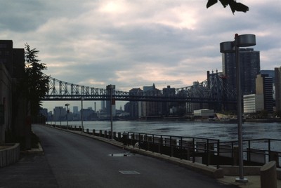
Roosevelt Island is located between Manhattan and Queens in the East River. The Queensboro Bridge crosses over the island, pictured at the left of the photo. Roosevelt Island has had many names over the years and once served as grounds for a state penitentiary a asylum for the mentally ill, and the first hospital to treat smallpox sufferers in the country.
During the early 20th century, the island was virtually abandoned. Mayor John Lindsay commissioned a redevelopment plan for the island in 1968. The design for the island created by Philip Johnson and John Burgee was displayed at the Metropolitan Museum of Art. The island was named Roosevelt Island in honor of President Franklin D. Roosevelt in 1973 by Governor Nelson Rockefeller and Mayor Lindsay. Redevelopment began on the island in the mid 1970s which included the creation of several housing complexes and an aerial Tramway for transportation. A subway station was added in 1990.
Rights
This object from the Chester E. Smolski photographic slides and publications, housed by the Rhode Island College Special Collections, and any of its digital surrogates are the intellectual property of Rhode Island College. This digital object is protected by copyright and/or related rights. The digital material presented here is licensed with a Creative Commons Attribution-NonCommercial-ShareAlike 4.0 International License. This content can be used, shared, or adapted for educational and scholarly purposes. For permissions to use this item please contact digitalcommons@ric.edu. All uses must include appropriate attribution.
Creator 1 Role
Photographer
Recommended Citation
Chester E. Smolski photographic slides and publications, MSS-0041, Special Collections, James P. Adams Library, Rhode Island College.
Recommended Citation
Chester E. Smolski photographic slides and publications, MSS-0041, Special Collections, James P. Adams Library, Rhode Island College.
Keywords
Roosevelt Island; New York City; Queesboro bridge; city planning; redevelopment; land use; urban growth;
Notes
http://www.rioc.com/history.htm