

Preview
Date
1-1-1975
Description
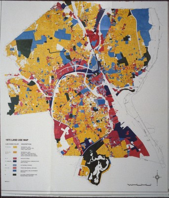
Map of land use in Providence during 1975. Yellow represents residential uses, the majority of which are one and two family dwellings. Orange represents three and four family dwellings including group quarters and lodging. Red is manufacturing. Navy is transportation, communication, and utilities. Light blue represents automobile parking. Vermillion is trade and general services. Medium Prussian blue is institutional and government services. Black is cultural, entertainment, and recreational services.
Rights
This object from the Chester E. Smolski photographic slides and publications, housed by the Rhode Island College Special Collections, and any of its digital surrogates are the intellectual property of Rhode Island College. This digital object is protected by copyright and/or related rights. The digital material presented here is licensed with a Creative Commons Attribution-NonCommercial-ShareAlike 4.0 International License. This content can be used, shared, or adapted for educational and scholarly purposes. For permissions to use this item please contact digitalcommons@ric.edu. All uses must include appropriate attribution.
Creator 1 Role
Photographer
Recommended Citation
Chester E. Smolski photographic slides and publications, MSS-0041, Special Collections, James P. Adams Library, Rhode Island College.
Recommended Citation
Chester E. Smolski photographic slides and publications, MSS-0041, Special Collections, James P. Adams Library, Rhode Island College.
Keywords
maps, land use, automobile parking, capital cities, city planning
Notes
Searched but could not find authorship or source of map.