

Preview
Date
1-1-1983
Description
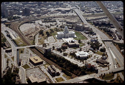
The railroad yard and parking lots that separated Providence's downtown from the Capital Center were locally referred to as a "Chinese wall." This 1983 view shows how the government offices were isolated from the rest of Providence by both these elements and Interstate 95 to the west.
Rights
This object from the Chester E. Smolski photographic slides and publications, housed by the Rhode Island College Special Collections, and any of its digital surrogates are the intellectual property of Rhode Island College. This digital object is protected by copyright and/or related rights. The digital material presented here is licensed with a Creative Commons Attribution-NonCommercial-ShareAlike 4.0 International License. This content can be used, shared, or adapted for educational and scholarly purposes. For permissions to use this item please contact digitalcommons@ric.edu. All uses must include appropriate attribution.
Creator 1 Role
Photographer
Recommended Citation
Chester E. Smolski photographic slides and publications, MSS-0041, Special Collections, James P. Adams Library, Rhode Island College.
Recommended Citation
Chester E. Smolski photographic slides and publications, MSS-0041, Special Collections, James P. Adams Library, Rhode Island College.
Keywords
aerial, capital city, state house, railroads, Chinese Wall
Notes
Woodward, PPS/AlAri Guide to Providence Architecture (Providence, 2003), 107.