

Preview
Date
Spring 4-1978
Description
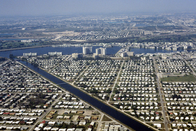
This aerial photograph looks north across Miami. Miami is one of the largest cities in the United States. Running across the photograph is Interstate 95. At frame left just north of the highway is the William's Island Country Club. Also seen is Greynolds Park Elementary School at frame right.
Rights
This object from the Chester E. Smolski photographic slides and publications, housed by the Rhode Island College Special Collections, and any of its digital surrogates are the intellectual property of Rhode Island College. This digital object is protected by copyright and/or related rights. The digital material presented here is licensed with a Creative Commons Attribution-NonCommercial-ShareAlike 4.0 International License. This content can be used, shared, or adapted for educational and scholarly purposes. For permissions to use this item please contact digitalcommons@ric.edu. All uses must include appropriate attribution.
Creator 1 Role
Photographer
Recommended Citation
Chester E. Smolski photographic slides and publications, MSS-0041, Special Collections, James P. Adams Library, Rhode Island College.
Recommended Citation
Chester E. Smolski photographic slides and publications, MSS-0041, Special Collections, James P. Adams Library, Rhode Island College.
Keywords
aerial, neighborhoods, housing, waterfront
Notes
http://en.wikipedia.org/wiki/Miami