

Preview
Date
Summer 6-1976
Description
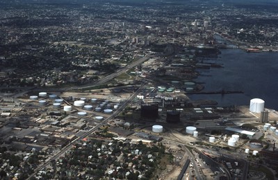
Aerial view showing Providence Port circa 1976. Allens Ave. runs diagnolly across the picture plane, and Interstate 95 enters the frame on the right, curves around the city and continues north to the horizon. To the east (frame right) the Fox Point Hurricane Barrier, just a decade old at the time, is visible, parallel to the Point St Bridge and Interstate 195, which was later relocated in 2008 to just south of the Hurricane Barrier.
Rights
This object from the Chester E. Smolski photographic slides and publications, housed by the Rhode Island College Special Collections, and any of its digital surrogates are the intellectual property of Rhode Island College. This digital object is protected by copyright and/or related rights. The digital material presented here is licensed with a Creative Commons Attribution-NonCommercial-ShareAlike 4.0 International License. This content can be used, shared, or adapted for educational and scholarly purposes. For permissions to use this item please contact digitalcommons@ric.edu. All uses must include appropriate attribution.
Creator 1 Role
Photographer
Recommended Citation
Chester E. Smolski photographic slides and publications, MSS-0041, Special Collections, James P. Adams Library, Rhode Island College.
Recommended Citation
Chester E. Smolski photographic slides and publications, MSS-0041, Special Collections, James P. Adams Library, Rhode Island College.
Keywords
aerial; Providence;
Notes
http://en.wikipedia.org/wiki/Interstate_195_(Rhode_Island-Massachusetts)