

Slide ID
CV-81-260
_pkUnique ID
CV81260
Slide Date
1981
Preview
Island
Fogo & Brava
Identifier
CV81260
Description
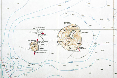
A contour map of the islands Fogo and Brava, a detail from a larger map showing the entire Cape Verde archipelago. Note the contour of Fogo, which contains Pico do Fogo, the highest point in Cape Verde, and active volcano.
Keywords
Contour Map; map; fogo; brava; volcano; pico do fogo; navigation;
Social Theme
Navigation
Box
1
Folder
6
Image Dimensions
5248x3523
Software
VueScan
Date Time Scanned
14-5-2012 12:00 AM
Color Space
RGB
File Size
1.6 MB
Document Type
Image
Recommended Citation
Baxter, David, "Map of Fogo and Brava" (1981). David Baxter papers: Cape Verde photographs. 456.
https://digitalcommons.ric.edu/baxter_gallery/456
Keywords
Contour Map; map; fogo; brava; volcano; pico do fogo; navigation;
Notes
Irwin, Aisling and Wilson, Colum. Cape Verde Islands: The Brandt Travel Guide. (Guilford, 2001) pp. 170-171