

Preview
Date
10-1969
Description
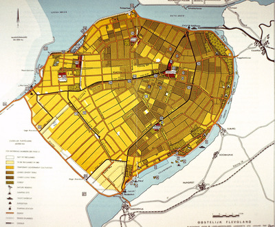
This map of Eastern Flevoland is from the 1960s and may be used in reference to images from the Smolski collection photographed in 1960.
See Smolski Images: Irrigation of wheat Northeast Polder Netherlands; Netherlands: Sluice Gates on Enclosure Dam & IJsselmeer; Netherlands: Enclosure Dam & IJsselmeer;
Rights
This object from the Chester E. Smolski photographic slides and publications, housed by the Rhode Island College Special Collections, and any of its digital surrogates are the intellectual property of Rhode Island College. This digital object is protected by copyright and/or related rights. The digital material presented here is licensed with a Creative Commons Attribution-NonCommercial-ShareAlike 4.0 International License. This content can be used, shared, or adapted for educational and scholarly purposes. For permissions to use this item please contact digitalcommons@ric.edu. All uses must include appropriate attribution.
Creator 1 Role
Photographer
Recommended Citation
Chester E. Smolski photographic slides and publications, MSS-0041, Special Collections, James P. Adams Library, Rhode Island College.
Recommended Citation
Chester E. Smolski photographic slides and publications, MSS-0041, Special Collections, James P. Adams Library, Rhode Island College.
Keywords
maps; city planning; flavoland; netherlands