

Preview
Date
1-1-1975
Description
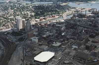
Aerial view of Providence downtown area. Among America’s oldest cities, Providence has a special sense of place. Like its contemporaries, it has been built and rebuilt many times. Development, however, has not resulted in wholesale destruction and replacement, but in complex layering, which reveals the built legacies created by generations of earlier residents. Together, Providence, as Rhode Island’s capital city, and Newport have since the American Revolution been the state’s economic, political, social, and architectural pacesetters.
Rights
This object from the Chester E. Smolski photographic slides and publications, housed by the Rhode Island College Special Collections, and any of its digital surrogates are the intellectual property of Rhode Island College. This digital object is protected by copyright and/or related rights. The digital material presented here is licensed with a Creative Commons Attribution-NonCommercial-ShareAlike 4.0 International License. This content can be used, shared, or adapted for educational and scholarly purposes. For permissions to use this item please contact digitalcommons@ric.edu. All uses must include appropriate attribution.
Creator 1 Role
Photographer
Recommended Citation
Chester E. Smolski photographic slides and publications, MSS-0041, Special Collections, James P. Adams Library, Rhode Island College.
Recommended Citation
Chester E. Smolski photographic slides and publications, MSS-0041, Special Collections, James P. Adams Library, Rhode Island College.
Keywords
aerial, city planning, land use, downtown, Providence River, Dunkin Donuts Center, skyline, skyscrapers, highways, Providene River
Notes
Jordy, Buildings of Rhode Island (Oxford, 2004), 29.