

Preview
Date
Winter 1-1978
Description
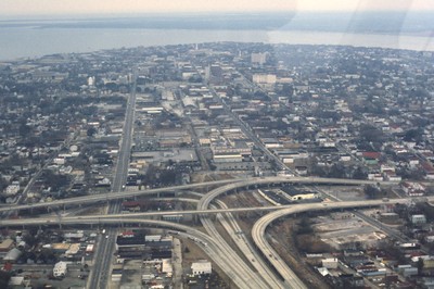
This aerial captures the meeting of Highway 26 with U.S. 17 in downtown Charleston, South Carolina. Highway 26 consists of the major roads running horizontal to the right of the split, while U.S. 17 runs perpendicular to it and continues veering off to the left. Highway 26 originates at the intersection of U.S. 11W and U.S. 23 in Kingsport, Tennessee and runs until this intersection with U.S. 17.
Rights
This object from the Chester E. Smolski photographic slides and publications, housed by the Rhode Island College Special Collections, and any of its digital surrogates are the intellectual property of Rhode Island College. This digital object is protected by copyright and/or related rights. The digital material presented here is licensed with a Creative Commons Attribution-NonCommercial-ShareAlike 4.0 International License. This content can be used, shared, or adapted for educational and scholarly purposes. For permissions to use this item please contact digitalcommons@ric.edu. All uses must include appropriate attribution.
Creator 1 Role
Photographer
Recommended Citation
Chester E. Smolski photographic slides and publications, MSS-0041, Special Collections, James P. Adams Library, Rhode Island College.
Recommended Citation
Chester E. Smolski photographic slides and publications, MSS-0041, Special Collections, James P. Adams Library, Rhode Island College.
Keywords
Interstate 26, U.S. 17, South Carolina, Charleston, highway interchange, aerial, downtown
Notes
http://en.wikipedia.org/wiki/Interstate_26
(accessed 1 Dec 2011)