

Preview
Date
1-1-1987
Description
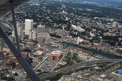
Aerial showing the east side and new additions to the old Financial District. These include: the building at Old Stone Square (Edward Larrabee Barnes, 1984), 50 Kennedy Plaza (a.k.a. Fleet Center, Helmut, Obata & Kassebaum, 1985), One Financial Plaza (a.k.a Soveign Bank Tower, formerly Hospital Trust Tower, John Carl Warnecke, 1970-73) and Textron Tower (Shreve, Lamb & Harmon, 1969-72).
Rights
This object from the Chester E. Smolski photographic slides and publications, housed by the Rhode Island College Special Collections, and any of its digital surrogates are the intellectual property of Rhode Island College. This digital object is protected by copyright and/or related rights. The digital material presented here is licensed with a Creative Commons Attribution-NonCommercial-ShareAlike 4.0 International License. This content can be used, shared, or adapted for educational and scholarly purposes. For permissions to use this item please contact digitalcommons@ric.edu. All uses must include appropriate attribution.
Creator 1 Role
Photographer
Recommended Citation
Chester E. Smolski photographic slides and publications, MSS-0041, Special Collections, James P. Adams Library, Rhode Island College.
Recommended Citation
Chester E. Smolski photographic slides and publications, MSS-0041, Special Collections, James P. Adams Library, Rhode Island College.
Keywords
aerial, highway, city planning, downtowns, skyline, skyscrapers, Providence River
Notes
Bibliography: Woodward, Wm McKenzie and Edward F. Sanderson. "Providence: A Citywide Survey of Historical Resources." Rhode Island Historical Preservation Commission, 1986, pp. 193, 224, 238. Woodward, William McKenzie. "Pps/aiari Guide to Providence Architecture." Providence, RI: Providence Preservation Society, 2003, pp. 102.