

Preview
Date
1-1-1987
Description
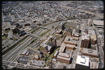
The Weybosset Hill area is bounded by Empire St. on the east, Broad and Washington Streets on the south and north, and Interstate 95 on the west. Redevelopment of this area stemmed from a 1959 recommendation of the City Plan Commission's master plan for Providence. Weybosset Hill cut off downtown from the West Side by blocking Westminster Street. Cathedral Square appears in the center of the photo.
Rights
This object from the Chester E. Smolski photographic slides and publications, housed by the Rhode Island College Special Collections, and any of its digital surrogates are the intellectual property of Rhode Island College. This digital object is protected by copyright and/or related rights. The digital material presented here is licensed with a Creative Commons Attribution-NonCommercial-ShareAlike 4.0 International License. This content can be used, shared, or adapted for educational and scholarly purposes. For permissions to use this item please contact digitalcommons@ric.edu. All uses must include appropriate attribution.
Recommended Citation
Chester E. Smolski photographic slides and publications, MSS-0041, Special Collections, James P. Adams Library, Rhode Island College.
Recommended Citation
Chester E. Smolski photographic slides and publications, MSS-0041, Special Collections, James P. Adams Library, Rhode Island College.
Keywords
aerial, city planning, highways, I-95, Weybosset Hill, Cathedral Square
Notes
Bibliography: Woodward, W.M. McKenzie. PPS/AlAri Guide to Providence Architecture. Providence Preservation Society, 2003. pp. 291-292.