

Preview
Date
1990
Description
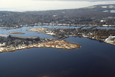
This aerial photograph was taken over Warren and looks west across Barrington and to Narragansett Bay. This photograph shows the distinctive shoreline of Belcher Cover and Tyler Point. Barrington had been a part of Warren from the 1747 until 1770. Visible at the from left is one of the textile mills built in Warren in the late nineteenth century after the decline of the whaling industry.
Rights
This object from the Chester E. Smolski photographic slides and publications, housed by the Rhode Island College Special Collections, and any of its digital surrogates are the intellectual property of Rhode Island College. This digital object is protected by copyright and/or related rights. The digital material presented here is licensed with a Creative Commons Attribution-NonCommercial-ShareAlike 4.0 International License. This content can be used, shared, or adapted for educational and scholarly purposes. For permissions to use this item please contact digitalcommons@ric.edu. All uses must include appropriate attribution.
Creator 1 Role
Photographer
Recommended Citation
Chester E. Smolski photographic slides and publications, MSS-0041, Special Collections, James P. Adams Library, Rhode Island College.
Recommended Citation
Chester E. Smolski photographic slides and publications, MSS-0041, Special Collections, James P. Adams Library, Rhode Island College.
Keywords
aerial, waterfront, colonial cities, mills, neighborhoods, Narragansett Bay
Notes
http://en.wikipedia.org/wiki/Barrington,_Rhode_Island
http://en.wikipedia.org/wiki/Warren,_Rhode_Island