

Preview
Date
2-1993
Description
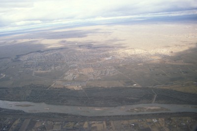
This image is showing an aerial view of the Rio Grande River. It is considered the fourth or fifth longest river system in North America. The river passes through the states of Colorado, New Mexico and Texas, thereby forming a natural border between the United States and Mexico. Since historic time, the river’s flow has decreased significantly due to the extreme water use of surrounding nearby cities. This results with barely one fifth of the total flow reaching the sea.
Rights
This object from the Chester E. Smolski photographic slides and publications, housed by the Rhode Island College Special Collections, and any of its digital surrogates are the intellectual property of Rhode Island College. This digital object is protected by copyright and/or related rights. The digital material presented here is licensed with a Creative Commons Attribution-NonCommercial-ShareAlike 4.0 International License. This content can be used, shared, or adapted for educational and scholarly purposes. For permissions to use this item please contact digitalcommons@ric.edu. All uses must include appropriate attribution.
Creator 1 Role
Photographer
Recommended Citation
Chester E. Smolski photographic slides and publications, MSS-0041, Special Collections, James P. Adams Library, Rhode Island College.
Recommended Citation
Chester E. Smolski photographic slides and publications, MSS-0041, Special Collections, James P. Adams Library, Rhode Island College.
Keywords
aerial, Rio Grande, rivers, Albuquerque
Notes
http://en.wikipedia.org/wiki/Rio_Grande