

Preview
Date
1-1-1993
Description
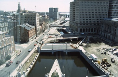
This photo shows work in progress in relocating Suicide Circle and uncovering and re-channeling the Mosshasuck and Woonasquatucket Rivers. Newly constructed Washington Street Bridge is in the foreground, but the old Fulton Street entrance to Suicide Circle is still in use to the south. Ultimately the Providence River will be re-channeled with pedestrian walkways along the old harbor.
Rights
This object from the Chester E. Smolski photographic slides and publications, housed by the Rhode Island College Special Collections, and any of its digital surrogates are the intellectual property of Rhode Island College. This digital object is protected by copyright and/or related rights. The digital material presented here is licensed with a Creative Commons Attribution-NonCommercial-ShareAlike 4.0 International License. This content can be used, shared, or adapted for educational and scholarly purposes. For permissions to use this item please contact digitalcommons@ric.edu. All uses must include appropriate attribution.
Creator 1 Role
Photographer
Recommended Citation
Chester E. Smolski photographic slides and publications, MSS-0041, Special Collections, James P. Adams Library, Rhode Island College.
Recommended Citation
Chester E. Smolski photographic slides and publications, MSS-0041, Special Collections, James P. Adams Library, Rhode Island College.
Keywords
city planning, Moshassuck River, Woonasquatucket River, river relocation, public spaces, water front, cityscape, downtown revitalization, urban renewal
Notes
Bibliography: Farbstein, Jay and Emily Axelrod, Robert Shibley and Richard Werner. "Providence River Relocation: Providence, Rhode Island." Bruner Foundation, 2004, www.rudybruneraward.org/wp-content/uploads/2016/08/06_providence.pdf. Accessed 19 Jan. 2017.