

Preview
Date
1-1-1976
Description
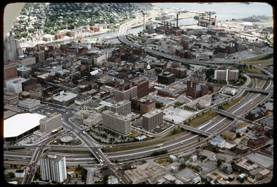
Aerial view looking west by southwest. I-95 junction with I-195. The Providence Civic Center (Dunkin Donuts Center), which opened in 1972 is at the lower left. Buildings in this photograph that have since been demolished include the circular Gulf station, the old police station, the Outlet Company, and the Crown Hotel adjacent to it. The vacant space on Green St. is now occupied by apartments at 4 Cathedral Square and the empty lot at 280 Washington Street became Grace Church Apartments.
Rights
This object from the Chester E. Smolski photographic slides and publications, housed by the Rhode Island College Special Collections, and any of its digital surrogates are the intellectual property of Rhode Island College. This digital object is protected by copyright and/or related rights. The digital material presented here is licensed with a Creative Commons Attribution-NonCommercial-ShareAlike 4.0 International License. This content can be used, shared, or adapted for educational and scholarly purposes. For permissions to use this item please contact digitalcommons@ric.edu. All uses must include appropriate attribution.
Creator 2 Dates
1972
Creator 2 Role
Architect firm (Civic Center)
Recommended Citation
Chester E. Smolski photographic slides and publications, MSS-0041, Special Collections, James P. Adams Library, Rhode Island College.
Recommended Citation
Chester E. Smolski photographic slides and publications, MSS-0041, Special Collections, James P. Adams Library, Rhode Island College.
Keywords
aerials, highways, land use, downtown
Notes
Bibliography: Woodward, W.M. McKenzie. PPS/AlAri Guide to Providence Architecture. Providence Preservation Society, 2003. pp. 306.