

Preview
Date
1-1-1987
Description
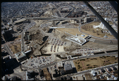
This image shows the transformation of Capital Center in progress. Francis Street construction is complete up until the over-passed train tracks and the bridge over the Woonasquatucket River. The former train tracks have been removed, but the land that turned into Memorial Boulevard is still dirt lot. Similarly, Providence Place Mall is years away from construction, but the paths of the highway access ramps under construction are beginning to suggest its future shape. Providence Station is the only completed element.
Rights
This object from the Chester E. Smolski photographic slides and publications, housed by the Rhode Island College Special Collections, and any of its digital surrogates are the intellectual property of Rhode Island College. This digital object is protected by copyright and/or related rights. The digital material presented here is licensed with a Creative Commons Attribution-NonCommercial-ShareAlike 4.0 International License. This content can be used, shared, or adapted for educational and scholarly purposes. For permissions to use this item please contact digitalcommons@ric.edu. All uses must include appropriate attribution.
Recommended Citation
Chester E. Smolski photographic slides and publications, MSS-0041, Special Collections, James P. Adams Library, Rhode Island College.
Recommended Citation
Chester E. Smolski photographic slides and publications, MSS-0041, Special Collections, James P. Adams Library, Rhode Island College.
Keywords
aerials, city planning, cityscape, highways, Capital Center, urban renewal, railroads, state house, automobile parking, Woonasquatucket River
Notes
Bibliography: Leazes, Francis J. and Mark T. Motte, Providence, the Renaissance City. Boston: Northeastern University Press, 2004, pp. 90-96.