

Preview
Date
Spring 4-1-1999
Description
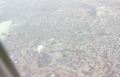
This aerial view looks south west across South Providence and into Cranston. Seen prominantly in the lower left is the Rhode Island Hospital complex, with the Hasbro Children’s Hospital which was only recently completed at the time of the photograph. At the center bottom is the interchange of Interstate 195 and 95, which was relocated in the mid 2000’s. Roger Williams Park, with it’s cluster of lakes is visible at the top center of the frame, with Mashapaug and Spectacle Ponds just west at the top right.
Rights
This object from the Chester E. Smolski photographic slides and publications, housed by the Rhode Island College Special Collections, and any of its digital surrogates are the intellectual property of Rhode Island College. This digital object is protected by copyright and/or related rights. The digital material presented here is licensed with a Creative Commons Attribution-NonCommercial-ShareAlike 4.0 International License. This content can be used, shared, or adapted for educational and scholarly purposes. For permissions to use this item please contact digitalcommons@ric.edu. All uses must include appropriate attribution.
Creator 1 Role
Photographer
Recommended Citation
Chester E. Smolski photographic slides and publications, MSS-0041, Special Collections, James P. Adams Library, Rhode Island College.
Recommended Citation
Chester E. Smolski photographic slides and publications, MSS-0041, Special Collections, James P. Adams Library, Rhode Island College.
Keywords
aerial; Providence;