

Preview
Date
Spring 4-1-1999
Description
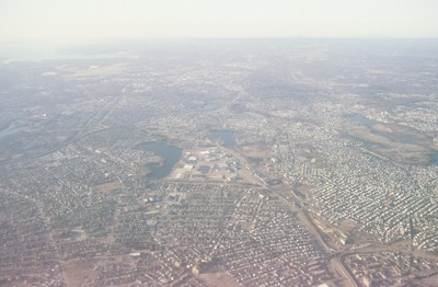
This south looking aerial view, photographed in the late 1990’s, shows South Providence neighborhood of Providence and a bit of Cranston. The two water bodies seen center frame are Mashapaug Pond and Spectacle Pond (left to right). To the east is Roger Williams Park, and to the north (bottom center frame) is the Cranston St. Armory. State Highway 10 and 6 interchange at the lower right, with Rt. 10 curving across the picture plane and connecting with Interstate 95 just east of Mashapaug Pond (center left).
Rights
This object from the Chester E. Smolski photographic slides and publications, housed by the Rhode Island College Special Collections, and any of its digital surrogates are the intellectual property of Rhode Island College. This digital object is protected by copyright and/or related rights. The digital material presented here is licensed with a Creative Commons Attribution-NonCommercial-ShareAlike 4.0 International License. This content can be used, shared, or adapted for educational and scholarly purposes. For permissions to use this item please contact digitalcommons@ric.edu. All uses must include appropriate attribution.
Creator 1 Role
Photographer
Recommended Citation
Chester E. Smolski photographic slides and publications, MSS-0041, Special Collections, James P. Adams Library, Rhode Island College.
Recommended Citation
Chester E. Smolski photographic slides and publications, MSS-0041, Special Collections, James P. Adams Library, Rhode Island College.
Keywords
aerial; Providence;