

Preview
Date
January 1980
Description
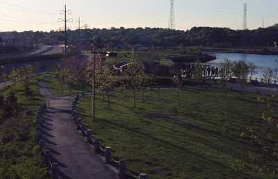
India Point Park features 18 acres of open space, graceful trees, and walking paths along its 3,600-foot shoreline. Located at the confluence of the Seekonk and Providence Rivers where they widen into Narragansett Bay, the Park is the only broad expanse of Bay shoreline in Providence accessible to the public. This park is heavily used and of Providence parks it serves the most diverse population. Groups using it include the Mexican Soccer League, the Cape Verdean Festival, Brown and RISD students, and the Boys and Girls Club of Fox Point, which is the city’s most diverse neighborhood. The Park has undergone in recent years a major landscaping reconstruction intended to increase pedestrian traffic significantly. (date of photograph is approximated)
Rights
This object from the Chester E. Smolski photographic slides and publications, housed by the Rhode Island College Special Collections, and any of its digital surrogates are the intellectual property of Rhode Island College. This digital object is protected by copyright and/or related rights. The digital material presented here is licensed with a Creative Commons Attribution-NonCommercial-ShareAlike 4.0 International License. This content can be used, shared, or adapted for educational and scholarly purposes. For permissions to use this item please contact digitalcommons@ric.edu. All uses must include appropriate attribution.
Creator 1 Role
Photographer
Recommended Citation
Chester E. Smolski photographic slides and publications, MSS-0041, Special Collections, James P. Adams Library, Rhode Island College.
Recommended Citation
Chester E. Smolski photographic slides and publications, MSS-0041, Special Collections, James P. Adams Library, Rhode Island College.
Keywords
parks, urban parks, waterfront
Notes
http://wikimapia.org/15699454/India-Point-Park