

Preview
Date
Spring 5-1985
Description
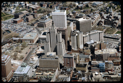
Downtown Providence is the result of a westward expansion from Market Square, the town’s first commercial center. The gradual transition of business activity across the Providence River in the early years of the nineteenth century resulted in extensive land filling, gradual at first but much accelerated by the insertion of the rail lines along the north edge of the city’s center in the late 1840s. The presence of the railroad reinforced and consolidated the importance of this precinct as the city’s commercial center.
Rights
This object from the Chester E. Smolski photographic slides and publications, housed by the Rhode Island College Special Collections, and any of its digital surrogates are the intellectual property of Rhode Island College. This digital object is protected by copyright and/or related rights. The digital material presented here is licensed with a Creative Commons Attribution-NonCommercial-ShareAlike 4.0 International License. This content can be used, shared, or adapted for educational and scholarly purposes. For permissions to use this item please contact digitalcommons@ric.edu. All uses must include appropriate attribution.
Recommended Citation
Chester E. Smolski photographic slides and publications, MSS-0041, Special Collections, James P. Adams Library, Rhode Island College.
Recommended Citation
Chester E. Smolski photographic slides and publications, MSS-0041, Special Collections, James P. Adams Library, Rhode Island College.
Keywords
aerial; downtown;
Notes
see Wm. McKenzie Woodward, PPS/AlAri Guide to Providence Architecture (s.l., 2003) pp. 77.