

Preview
Date
Spring 5-8-1985
Description
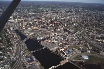
Manchester Street Power Station is located on 12 acres of land on Point Street in Providence. The Post-Modern 1990s addition was added by William D. Warner Architects & Planners. It produces enough electricity to power about 112,000 homes, using natural gas as its fuel. Manchester Street consists of three combined-cycle generating units, which produce electricity and steam for industrial use.
Rights
This object from the Chester E. Smolski photographic slides and publications, housed by the Rhode Island College Special Collections, and any of its digital surrogates are the intellectual property of Rhode Island College. This digital object is protected by copyright and/or related rights. The digital material presented here is licensed with a Creative Commons Attribution-NonCommercial-ShareAlike 4.0 International License. This content can be used, shared, or adapted for educational and scholarly purposes. For permissions to use this item please contact digitalcommons@ric.edu. All uses must include appropriate attribution.
Creator 1 Role
Photographer
Recommended Citation
Chester E. Smolski photographic slides and publications, MSS-0041, Special Collections, James P. Adams Library, Rhode Island College.
Recommended Citation
Chester E. Smolski photographic slides and publications, MSS-0041, Special Collections, James P. Adams Library, Rhode Island College.
Keywords
aerial; power plant; National Grid;
Notes
see Wm. Mckenzie Woodward, PPS/AIAri Guide to Providence Architecture (s.l., 2003), p. 124.
http://www.dom.com/about/stations/fossil/manchester-street-power-station.jsp