

Preview
Date
1983
Description
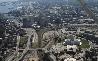
Seen here is an aerial view of the Rhode Island State House in Downtown Providence. The building was designed by McKim, Mead and White between 1892 and 1904. It is located on Smith Street. Also seen in this aerial is the Providence Financial District which consists of the Industrial Trust Co. (1928) and the Rhode Island Hospital Trust Co Building (1917, 1973). The view predates the creation of the Capital Center and the moving of the railway-tracks and the Chinese Wall.
Rights
This object from the Chester E. Smolski photographic slides and publications, housed by the Rhode Island College Special Collections, and any of its digital surrogates are the intellectual property of Rhode Island College. This digital object is protected by copyright and/or related rights. The digital material presented here is licensed with a Creative Commons Attribution-NonCommercial-ShareAlike 4.0 International License. This content can be used, shared, or adapted for educational and scholarly purposes. For permissions to use this item please contact digitalcommons@ric.edu. All uses must include appropriate attribution.
Creator 1 Role
Photographer
Creator 2 Role
Architects
Recommended Citation
Chester E. Smolski photographic slides and publications, MSS-0041, Special Collections, James P. Adams Library, Rhode Island College.
Recommended Citation
Chester E. Smolski photographic slides and publications, MSS-0041, Special Collections, James P. Adams Library, Rhode Island College.
Keywords
aerial; capitol; state house; Chinese Wall; Financial District; North Main Street
Notes
Woodward, PPS/AlAri Guide to Providence Architecture (Providence, 2003), 79,101,107.