

Preview
Date
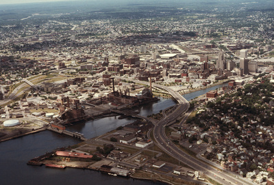
6-1-1976
Description
Downtown Providence from above, looking west across the Providence River into the cityscape. This 1976 view shows how Interstate 195 used to divide the city and occupy crucial downtown real estate. It was relocated in the 2000s to follow a more direct route to Interstate 95, crossing the Providence River adjacent to the Fox Point Hurricane Barrier. This photograph also displays the importance and reality of Providence's forming around the Moshassuck and Providence rivers, its original economic building under industrialization on the rivers.
Rights
This object from the Chester E. Smolski photographic slides and publications, housed by the Rhode Island College Special Collections, and any of its digital surrogates are the intellectual property of Rhode Island College. This digital object is protected by copyright and/or related rights. The digital material presented here is licensed with a Creative Commons Attribution-NonCommercial-ShareAlike 4.0 International License. This content can be used, shared, or adapted for educational and scholarly purposes. For permissions to use this item please contact digitalcommons@ric.edu. All uses must include appropriate attribution.
Recommended Citation
Chester E. Smolski photographic slides and publications, MSS-0041, Special Collections, James P. Adams Library, Rhode Island College.
Recommended Citation
Chester E. Smolski photographic slides and publications, MSS-0041, Special Collections, James P. Adams Library, Rhode Island College.
Keywords
downtown, aerial, cityscape, waterfront, highway relocation, highways
Notes
Bibliography: Leazes, Francis J. and Mark T. Motte, Providence, the Renaissance City. Boston: Northeastern University Press, 2004, p. 39. Binder, Jacob. "Divided by Pavement, Divided by Race: 1-195's Impact on Providece." Brown Political Review, 19 Mar. 2016, www.brownpoliticalreview.org/2016/03/divided-pavement-divided-race-195s-impact-providence/. Accessed 15 Mar. 2017.