

Preview
Date
6-1981
Description
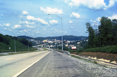
Clarksburg is a city in West Virginia with a population of 16,578 at the 2010 census. This 1981 photograph, taken on U.S. Route 50 shows the approach to the city and the hilly terrain that the city is built within. This section of Rt. 50 is part of Corridor D in the Appalachian Development Highway System. The system was established in 1965 to boost economic growth in Appalachia.
Rights
This object from the Chester E. Smolski photographic slides and publications, housed by the Rhode Island College Special Collections, and any of its digital surrogates are the intellectual property of Rhode Island College. This digital object is protected by copyright and/or related rights. The digital material presented here is licensed with a Creative Commons Attribution-NonCommercial-ShareAlike 4.0 International License. This content can be used, shared, or adapted for educational and scholarly purposes. For permissions to use this item please contact digitalcommons@ric.edu. All uses must include appropriate attribution.
Creator 1 Role
Photographer
Recommended Citation
Chester E. Smolski photographic slides and publications, MSS-0041, Special Collections, James P. Adams Library, Rhode Island College.
Recommended Citation
Chester E. Smolski photographic slides and publications, MSS-0041, Special Collections, James P. Adams Library, Rhode Island College.
Keywords
Appalachia, cityscape, regionalization, traffic flow, highways, U.S. Rt 50
Notes
http://en.wikipedia.org/wiki/Clarksburg,_West_Virginia
http://en.wikipedia.org/wiki/U.S._Route_50
http://en.wikipedia.org/wiki/U.S._Route_50_in_West_Virginia
http://maps.google.com/maps?hl=en&safe=off&client=safari&rls=en&q=clarksburg+wv&um=1&ie=UTF-8&hq=&hnear=0x884a67cb09eb7e77:0x5de91ece70cc47e0,Clarksburg,+WV&gl=us&ei=HdRfToWYGajG0AHw27m4Dg&sa=X&oi=geocode_result&ct=image&resnum=1&ved=0CBcQ8gEwAA