

Preview
Date
January 1987
Description
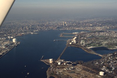
The Providence River flows from Narragansett Bay and splits into Woonasquatucket and Moshassuck Rivers, which go through Providence. When it was founded, the Providence Harbor played a significant role in the growth of fishing and trade in Providence, as it was more protected from the severe weather conditions of the sea than the Newport Harbor as well as having Colonial forts on either side of the river to protect from the British. In the 1980s the river was one affected by the River Relocation Project and slightly redirected.
Rights
This object from the Chester E. Smolski photographic slides and publications, housed by the Rhode Island College Special Collections, and any of its digital surrogates are the intellectual property of Rhode Island College. This digital object is protected by copyright and/or related rights. The digital material presented here is licensed with a Creative Commons Attribution-NonCommercial-ShareAlike 4.0 International License. This content can be used, shared, or adapted for educational and scholarly purposes. For permissions to use this item please contact digitalcommons@ric.edu. All uses must include appropriate attribution.
Creator 1 Role
Photographer
Recommended Citation
Chester E. Smolski photographic slides and publications, MSS-0041, Special Collections, James P. Adams Library, Rhode Island College.
Recommended Citation
Chester E. Smolski photographic slides and publications, MSS-0041, Special Collections, James P. Adams Library, Rhode Island College.
Keywords
aerial, rivers, Providence River
Notes
Bibliography: "History." Providence Working Waterfront Alliance, 2007, www.providenceworkingwaterfront.org/index.php/providences-working-waterfront/history. Accessed 19 Jan. 2017. Leazes, Francis J. and Mark T. Motte, Providence, the Renaissance City. Boston: Northeastern University Press, 2004, pp. 115-119.