

Preview
Date
1977
Description
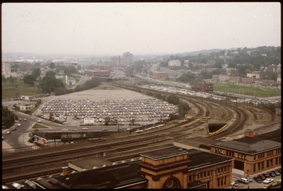
Prior to the construction of Waterplace Park railroad tracks and parking lots separated the different districts of downtown Providence. This barrier was locally referred to as a, "Chinese wall." This 1977 view shows Providence before its dramatic rebirth from “gritty wasteland of neglected waterways, derelict railroad yards, and vast parking lots” to “one of the nation’s most attractive urban environments” (Leazes and Motte). Much of this redesign happened after the 1986 burning of Union station, and the River Relocation Project in order to repair downtown.
Rights
This object from the Chester E. Smolski photographic slides and publications, housed by the Rhode Island College Special Collections, and any of its digital surrogates are the intellectual property of Rhode Island College. This digital object is protected by copyright and/or related rights. The digital material presented here is licensed with a Creative Commons Attribution-NonCommercial-ShareAlike 4.0 International License. This content can be used, shared, or adapted for educational and scholarly purposes. For permissions to use this item please contact digitalcommons@ric.edu. All uses must include appropriate attribution.
Recommended Citation
Chester E. Smolski photographic slides and publications, MSS-0041, Special Collections, James P. Adams Library, Rhode Island College.
Recommended Citation
Chester E. Smolski photographic slides and publications, MSS-0041, Special Collections, James P. Adams Library, Rhode Island College.
Keywords
aerials, automobile parking, railroads, Capital Center, downtown, land use, urban transportation, urban renewal, dead downtown, Chinese Wall, Union Station, Waterplace Park
Notes
Bibliography: Leazes, Francis J. and Mark T. Motte, Providence, the Renaissance City. Boston: Northeastern University Press, 2004, pp. 125-132.