

Preview
Date
Summer 6-1978
Description
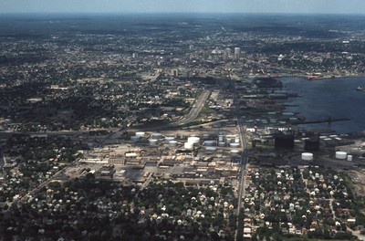
This aerial shows I-95 in the left-center and Allens Avenue at right-center heading north into downtown. Lining the western bank of Providence Harbor is the industrial waterfront which until recently had been “long-overlooked” despite its historic role as the source Providence’s original prosperity. Today it stands as one of only two deep-water ports in New England, and one of the busiest multimodal facilities for international and domestic distribution.
Rights
This object from the Chester E. Smolski photographic slides and publications, housed by the Rhode Island College Special Collections, and any of its digital surrogates are the intellectual property of Rhode Island College. This digital object is protected by copyright and/or related rights. The digital material presented here is licensed with a Creative Commons Attribution-NonCommercial-ShareAlike 4.0 International License. This content can be used, shared, or adapted for educational and scholarly purposes. For permissions to use this item please contact digitalcommons@ric.edu. All uses must include appropriate attribution.
Creator 1 Role
Photographer
Recommended Citation
Chester E. Smolski photographic slides and publications, MSS-0041, Special Collections, James P. Adams Library, Rhode Island College.
Recommended Citation
Chester E. Smolski photographic slides and publications, MSS-0041, Special Collections, James P. Adams Library, Rhode Island College.
Keywords
aerial; Port of Providence; Providence;
Notes
http://www.provport.com/