

Slide ID
CV-81-308
_pkUnique ID
CV81308
Slide Date
1-1-1981
Preview
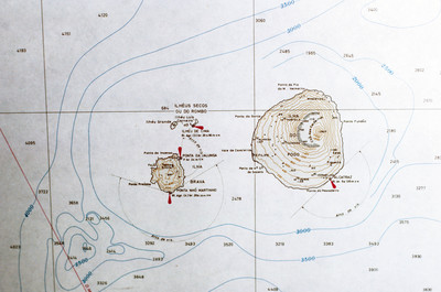
Island
Fogo
Identifier
CV81308
Date
January 1981
Description
Contour map of the island, Fogo. The island, located in the Cape Verde archipelago, is mostly a large volcano, Pico do Fogo. It is laregly dormant, but has had intermittent eruptions, the last of which occurring in 1995.
Keywords
maps, map, fogo, volcano, contour
Box
1
Folder
7
Image Dimensions
5229x3468
Software
VueScan
Date Time Scanned
May 2012
Color Space
RGB
File Size
1.6 MB
Document Type
Image
Recommended Citation
Baxter, David, "Map of Fogo" (1981). David Baxter papers: Cape Verde photographs. 505.
https://digitalcommons.ric.edu/baxter_gallery/505
Keywords
maps, map, fogo, volcano, contour